
Truro Township Previous Residents Sources
The backward trail changes with the era. Start with the present parcel because the Auditor connects the physical address to a parcel ID, legal description, transfers, taxing districts, and map context. Then use the Recorder for a documented title chain. City and telephone directories can supply an occupant lead for a publication year, while released federal census schedules capture a household at the census date. Maps, Probate, and obituary material help test a trail rather than replace it.
| Source | Years It Covers | Where Held | What It Shows |
|---|---|---|---|
| Recorder archival deed index | 1804–1913 | Franklin County Recorder archives and legacy guidance | Historic grantor or grantee route and book or volume references |
| Recorder deed index | From January 2, 1914 | Franklin County Recorder systems | Later recorded deeds and title parties |
| Auditor historic parcel sheets | 1920–December 31, 1998 | Franklin County Auditor historic-sheet tools | Parcel and mapping snapshots |
| Auditor Parcel Archive | 1995–present | Franklin County Auditor Online Tools | Parcel map history |
| Reynoldsburg–Truro Historical Society (RTHS) tax maps and parcel sheets | Tax maps 1895–1940; relevant sheets 1920–1988 | Reynoldsburg–Truro Historical Society | Local map, parcel, and annexation context |
| Columbus Metropolitan Library (CML) directories and reverse material | Shelf from 1841; street access from 1911 | Columbus Metropolitan Library | Published household or address leads |
| Federal census | Released schedules through 1950 | National Archives and library genealogy access | Household snapshot, not an exact move date |
These sources should not be read as one seamless address index. Use the date range to choose the first place to look. A parcel transfer answers a title question; a directory can place an occupant; a census can describe a household; and a map can show the land or road context. Each needs its own citation and date.
Old Truro Township Parcel Clues
Franklin County Auditor Property Search is the starting point for an address that still maps to a county parcel. Its public modes include owner, address, parcel ID, subdivision and condo, advanced, map, and intersection. A property card can show the parcel ID, site address, owner mailing/contact address, legal description, tax district, City or Village, Township, ZIP, transfer date, price, instrument, and mapping tabs. The card’s owner mailing field is a tax-contact field, not the physical site address.
Copy the legal description before moving to old records. It is the durable bridge when a street has been renamed, a rural tract was subdivided, a municipal boundary changed, or an old document never used a modern postal address. Auditor search takes parcel digits without dashes. The Treasurer uses a different display pattern, so keep the source-specific format as shown rather than editing it to look alike.
Truro Township Previous Residents Deed Chain
Use the current property card’s legal description, transfer details, and parcel number to reach the Franklin County Recorder Official Records Search. The Recorder is not a guaranteed historic street-address index. It works best with a party name, subdivision or legal description, document type, document number, recorded date, full-text OCR, or book, volume, and page. The aim is to document title parties first, then compare those dates with household sources.
- Search the Auditor by physical address and preserve the site address, parcel ID, legal description, transfer date, price, instrument, and tax district.
- Use the current transfer or owner clue to locate the recorded conveyance and identify the seller, who is the grantor on that deed.
- Search that prior owner as a grantee in an earlier date range, then compare the legal description and deed details before extending the chain.
- Repeat only while the party and land description support continuity. Record the document type, date, book or volume reference, and any instrument number.
- Move to the appropriate archive or counter route when the chain crosses a system boundary or the document cannot be read online.
- Grantor
- The party conveying an interest in a recorded document.
- Grantee
- The party receiving that recorded interest.
- Chain of title
- The documented sequence of recorded transfers for the same land interest.
- Legal description
- The land description used in title records, often a subdivision, lot, block, or other parcel description that lasts longer than a street label.
A chain of title tracks recorded interests, not every person who lived at the address. Do not fill a gap with a same-surname hit unless the property description and dates support it.
Truro Township Deed Era Records
Franklin County’s historical record formats explain why an old trail can change tools. The detailed backward-trail table lists the Recorder archival deed index as 1804–1913. Earlier Recorder quick guidance identifies a “Grantee Deed Index 1804–1888.” Preserve both statements rather than silently treating them as one identical coverage claim. Ask the Recorder which index, letter, volume, page, or counter route applies to a particular document.
For documents recorded after May 15, 1997, the research identifies a 15-digit instrument number. Documents from October 10, 1980 through May 14, 1997 can have microfiche volume and page references, while earlier work uses book, volume, and page. Some early county records were destroyed in the 1879 fire, but the Recorder says most were reconstructed. That is a document-level verification warning, not proof that every early title is gone.
The Franklin County Recorder’s official search is the source for this Truro Township grantor and grantee view.
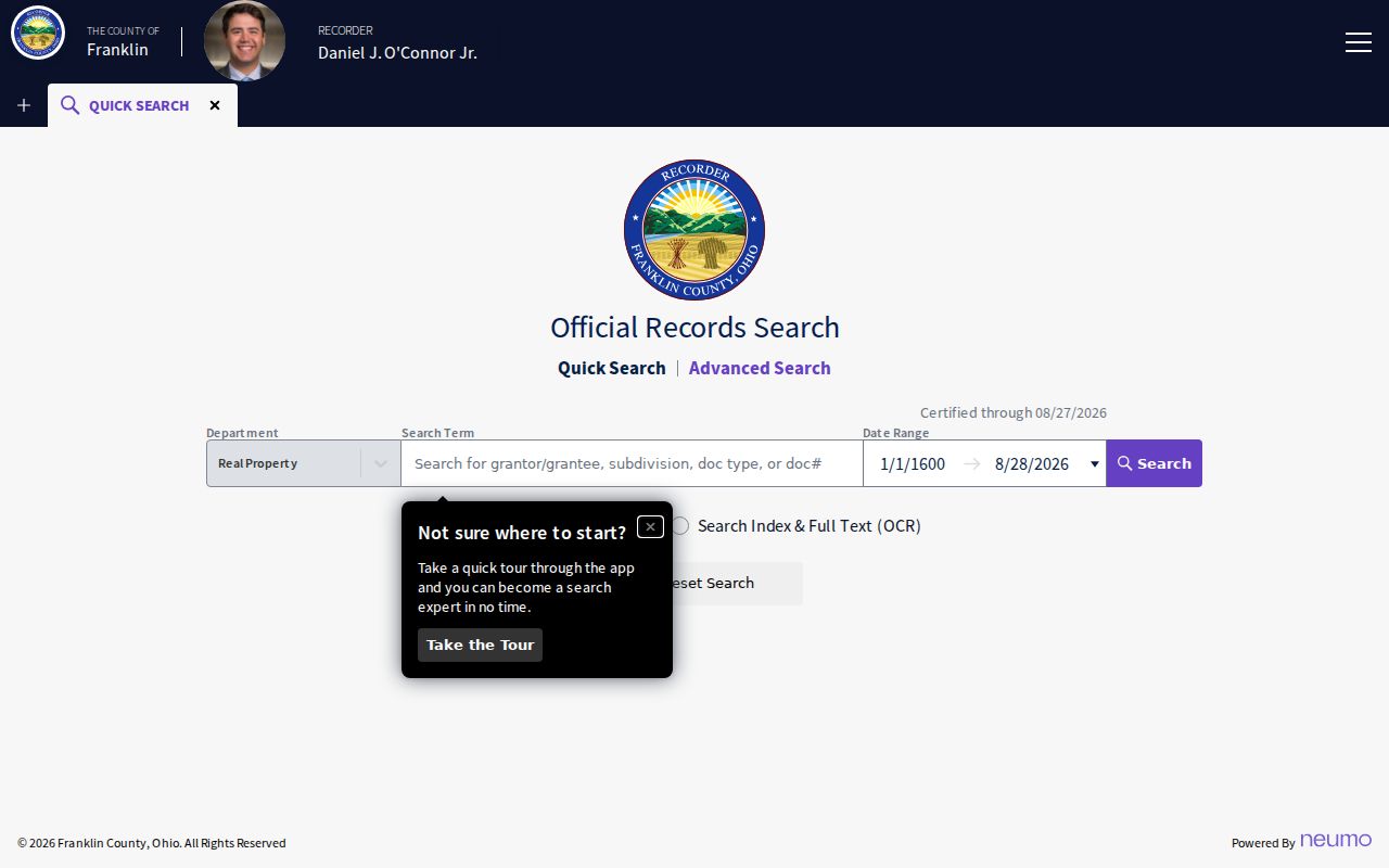
Use a document date and the legal description to keep a grantor or grantee result tied to the correct parcel rather than to a similar name.
Truro Township Address History Maps
Maps help establish what an address meant in its own era. Auditor historic parcel sheets cover 1920 through December 31, 1998, and the Parcel Archive covers 1995 to the present. RTHS reports Franklin County tax maps from 1895–1940, tax district lists from 1879, and relevant parcel sheets from 1920–1988. CML’s house-history guidance also points to deeds, directories, Sanborn maps, historical maps, and library collections as a local research sequence.
For earlier land context, Ohio History Connection has an 1842/1856/1883 Franklin County wall-map PDF with an 1842 Truro Township sheet, while Library of Congress cadastral maps cover 1856 and 1895. A name printed on one of those maps is a historic mapped landowner, not confirmed household occupancy. Sanborn resources cover Ohio maps from 1882–1962, but a researcher must confirm the relevant sheet includes the tract before claiming that it maps a particular address.
Truro Township Past Residents at Home
Title parties are only part of a house history. CML holds Columbus city directories back to 1841 and says reverse or street-address access begins in 1911. The 1917–18 and 1929–30 Simplex guides and the 1926 street-arranged phone book offer address-to-occupant routes for their published years. A directory is a published-year lead, so use it beside the title chain rather than in place of one.
A safe household flow is: address and parcel → legal description and recorded transfer → directory or reverse listing for the relevant year → released census → obituary or Probate endpoint. Use an address spelling exactly as printed. Check CML’s shelf when digitization skips a year, then compare the name, spouse notation, locality, and street wording across adjacent volumes. The historical collection details are on the Truro Township city directory page.
- Choose a directory volume nearest to a transfer or census date and note the page image.
- Check the years before and after for a move, a changed spelling, a spouse notation, or a missing listing.
- Use reverse material for 1911 and later when the street address is the starting point.
- Pair a decade-level directory clue with the released federal census, currently through 1950.
- Use an obituary or Probate estate only after the name and time period have independent support.
Truro Township Previous Residents Traps
Historic geography is a real source of false matches. Truro Township is a Franklin County township, yet parts of its historic territory now appear within Reynoldsburg and Columbus, with Brice and unincorporated pieces also relevant. Reynoldsburg’s official annexation table begins documenting annexations from Truro in 1954. A current postal city or municipal boundary cannot be projected backward onto an older deed, directory, permit, or map.
No official source established a township-wide street-numbering origin or global renumbering project, so do not invent one. RTHS does flag local continuity traps: part of Rodebaugh Road east of Waggoner was once Stewart Road, and Livingston Avenue has historical sections and becomes Slate Ridge Boulevard at Five Points. Verify the old road wording with a plat or map before treating a candidate record as the same address.
Truro Township Previous Residents Endpoints
Obituary, cemetery, and Probate sources can close a documented historical trail. CML’s Columbus News and Obituary Index covers obituaries from 1931–97 and selected Franklin-area articles from 1960–97. The Central Ohio News and Subject Index adds Ohio State Journal indexes from 1913–40 and a Columbus-newspaper index for 1811–1919. A date-specific CML obituary request can lead to the relevant newspaper item. These are event and family-history sources, not proof that a person owned or occupied a parcel at every point in time.
Silent Home Cemetery has more than 5,000 occupied graves and a 1917 mausoleum, but no public name-search index was verified. The practical route is a specific inquiry to the township or cemetery about a burial or lot ledger. Probate estates can identify a case path and fiduciary. Read the actual file for context, and remember that confidential categories remain unavailable.
Lawful use. Previous-resident research is for documented house, family, and local-history work. Do not use a name, address, or old record to track, contact, threaten, or harass a living person.